Aviation weather radar contouring reading helps you avoid dangerous storms
There’s so much more to aviation weather radar than simply turning it on and looking for red blobs to avoid. As long as we keep reading about convective weather related accidents, it’s safe to say that pilots still do not completely understand the ins and outs of using airborne weather radar. Even though radar technology has improved by leaps and bounds over the past several years, pilots are still getting caught in weather that is far beyond their flying capability and the capability of their aircraft.
Obviously the biggest safety rule that pertains to every pilot, regardless of his/her skill and experience level is avoid, avoid, avoid. In fact, stay at least 20 nautical miles away from a strong storm (yeah, that’s subjective, but err on the side of caution) and don’t fly directly over the top of a cell, unless you have at least 2000 feet of clearance, preferably more.
Being an expert on the operation of your weather radar is the next best thing, but that takes time and practice. Each echo on your screen tells a story – it’s up to you to be able to interpret what it is trying to tell you. Take contouring, for example….
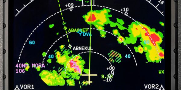
Contouring refers to the general appearance of a weather return. Correctly evaluating an echo using this technique can help you distinguish between a harmless rain shower or a killer storm. Convective activity is displayed by well defined edges. In other words, steeply contoured images where the radar colors are packed closely together indicates convection. So if the weather return shows green, yellow and red activity in close proximity, steer clear!
On the other hand, wide spacing of colors and ill defined edges indicate more non-threatening activity. It is also critical to evaluate the season and geographical location of the weather that you’re observing on the radar. Radar activity in January on the west coast is probably not convective, while a red return in Louisiana in July is something you should absolutely avoid!
Good judgement is ultimately required to correctly interpret aviation weather radar. Look at as many clues as you can and piece them all together to safely navigate around convective activity. Contouring is just one tool in the overall effort to safely arrive at your destination. Just remember, steep contouring, no matter the season, is always something you should avoid. ALWAYS!
RELATED READING
RELATED CTS TRAINING

