Aviation weather flying is getting safer and more exciting with technological advances
Aviation weather has been a challenge for pilots since the first brave soul flew through the clouds and came out the other side. We sure have come a long way since then, and apparently, the best is yet to come. Enhanced and synthetic vision can do everything from simply enhancing our normal vision to potentially turning the worst weather into the appearance of a clear, sunny day.
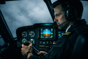
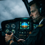
I remember the first time I flew a CATIII approach in real life. It was both exhilarating and terrifying at the same time. I’m not going to lie; it was more than a little uncomfortable to know that we were seconds from touchdown with nothing but gray clouds filling the windshield. On the other hand, watching the power levers slide back while the nose came up for the perfect flare and touchdown was mind-blowing. New technology available in modern aircraft helps the pilot drop the “terrifying” yet keep the exhilaration.
There are two types of new vision technologies that assist pilots in weather and terrain situations. Enhanced vision systems (EVS) are the more basic of the two options, and Smartview (SVS) technologies can give the pilot a clear view of the runway and surrounding obstacles, regardless of the actual weather outside.
EVS is based mainly on infrared sensors and has been in use for the last 15 years. The goal of EVS was to help the pilots who were flying their business aircraft into small and medium-sized airports that were not equipped with the expensive ground installations that enabled CAT II and III approaches in the worst of weather. The EVS imagery is shown in the Head Up Display (HUD), offering an enhancement to the pilot’s natural vision. Unfortunately, it has its limitations; for example, it is not able to see through clouds.

SVS technology is relatively newer within the last ten years and can give the pilot an accurate idea of their surroundings, regardless of the outside weather conditions. It does this by combining a database of topographical maps, the aircraft’s GPS location, and data from satellites.
Improved situational awareness is the goal of the SVS system. It achieves this by providing an easy to understand depiction of terrain using 3D images and information about the airport and runway environment. These benefits are invaluable for pilots who typically fly in and around mountainous terrain and fly into unfamiliar airports or areas with known low visibility. The SVS is also helpful on the ground at unfamiliar airports or when runway markings are limited or not available.
Advances in technology are critical as the demand for the next generation of pilots catches up to the current retirements. Soon the steam gauges will be gone and the younger pilots will look at old pictures in disbelief. Aviation weather is not going anywhere, though. Anything that makes our job easier and safer is more than welcome. It’s an exciting time to be a pilot!